Coding implementation
GeoClimate algorithms are implemented as functions in Groovy Scripts.
GeoClimate is organized in 3 modules (Figure 1).
- GeoIndicators is the main module. It contains all the algorithms to build the units of analysis, compute the corresponding indicators and classify urban fabric by type. The SpatialUnits script creates the units of analysis (currently blocks and TSU). The BuildingIndicators, BlockIndicators, RoadIndicators, RSUIndicators calculates morphological and topographical indicators respectively at building, block, road and RSU scales. The GenericIndicators script calculates indicators which can be applied to any scale (e.g. the area of a unit - building, block, RSU - or the aggregation of indicator from one scale to an other - mean building height within a block or a RSU). The TypologyClassification script classifies units to a certain type (currently building to UTRF and TSU to LCZ) based on indicators value. The DataUtil script facilitates data handling (e.g. join several tables). All functions contained in the previous scripts may be called individually. To run several of them in a row, workflows are available in the WorkflowGeoIndicators script. The main one perform all the analysis (green arrows Figure 1): it produces the units of analysis, compute the indicators at the base scales (building and road), computes indicators at block scale, aggregate indicators from lower to upper scale, compute indicators at RSU scale and then classify urban fabric.
- OSM module extracts and transforms the OSM data to the GeoClimate abstract model. Those data processing are specified in the two scripts InputDataLoading and InputDataFormating. The WorkflowOSM script chains algorithms (blue arrow Figure 1): it triggers the 2 scripts dedicated to the OSM data preparation and then the WorkflowGeoIndicators script. It is the main entry to specify the area to be processed, the indicators and the classifications to compute.
- BDTopo_V2 module follows the same logic as the OSM module except that it is dedicated to version 2.2 of the IGN BDTopo database
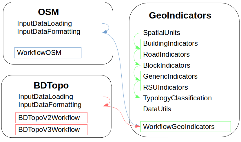
Figure 1. The GeoClimate modules
GeoClimate - documentation 2020 - 2024 -
This work is licensed under a Creative Commons Attribution-ShareAlike 4.0 International.
